


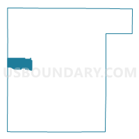
SCANDINAVIA - T 1 Voting District, Waupaca County, Wisconsin
About
Outline

Summary
| Unique Area Identifier | 698077 |
| Name | SCANDINAVIA - T 1 Voting District |
| County | Waupaca County |
| State | Wisconsin |
| Area (square miles) | 15.09 |
| Land Area (square miles) | 14.84 |
| Water Area (square miles) | 0.24 |
| % of Land Area | 98.38 |
| % of Water Area | 1.62 |
| Latitude of the Internal Point | 44.48645470 |
| Longtitude of the Internal Point | -89.15929030 |
Maps


Graphs
Select a template below for downloading or customizing gragh for SCANDINAVIA - T 1 Voting District, Waupaca County, Wisconsin


Neighbors
Neighoring Voting District (by Name) Neighboring Voting District on the Map
- AMHERST - T 2 Voting District, Portage County, WI
- IOLA - T 1 Voting District, Waupaca County, WI
- IOLA - T 2 Voting District, Waupaca County, WI
- Iola - V 2 Voting District, Waupaca County, WI
- Iola - V 3 Voting District, Waupaca County, WI
- NEW HOPE - T 1 Voting District, Portage County, WI
- SCANDINAVIA - T 2 Voting District, Waupaca County, WI
- Scandinavia - V 1 Voting District, Waupaca County, WI
- ST LAWRENCE - T 1 Voting District, Waupaca County, WI
Top 10 Neighboring County Subdivision (by Population) Neighboring County Subdivision on the Map
- Amherst town, Portage County, WI (1,325)
- Iola village, Waupaca County, WI (1,301)
- Scandinavia town, Waupaca County, WI (1,066)
- Iola town, Waupaca County, WI (971)
- New Hope town, Portage County, WI (718)
- St. Lawrence town, Waupaca County, WI (710)
- Scandinavia village, Waupaca County, WI (363)
Top 10 Neighboring Place (by Population) Neighboring Place on the Map
Top 10 Neighboring Unified School District (by Population) Neighboring Unified School District on the Map
- Waupaca School District, WI (15,851)
- Tomorrow River School District, WI (4,981)
- Iola-Scandinavia School District, WI (4,665)
Top 10 Neighboring State Legislative District Lower Chamber (by Population) Neighboring State Legislative District Lower Chamber on the Map
Top 10 Neighboring State Legislative District Upper Chamber (by Population) Neighboring State Legislative District Upper Chamber on the Map
Top 10 Neighboring 111th Congressional District (by Population) Neighboring 111th Congressional District on the Map
Top 10 Neighboring Census Tract (by Population) Neighboring Census Tract on the Map
- Census Tract 9606, Portage County, WI (5,249)
- Census Tract 9601, Portage County, WI (4,495)
- Census Tract 1004, Waupaca County, WI (4,413)
- Census Tract 1003, Waupaca County, WI (3,847)